Venezuela Map PowerPoint Google Slides Template


Product Description
When your presentation needs to communicate geographic, demographic, or economic information about Venezuela, a plain text slide simply does not do the job. This Venezuela Map Template gives researchers, educators, business analysts, policy presenters, and geopolitical consultants a visually authoritative, data-ready slide that combines a detailed 3D country map with infographic data panels, all fully editable in both Microsoft PowerPoint and Google Slides so your team can customize and present it on whichever platform your organization relies on.
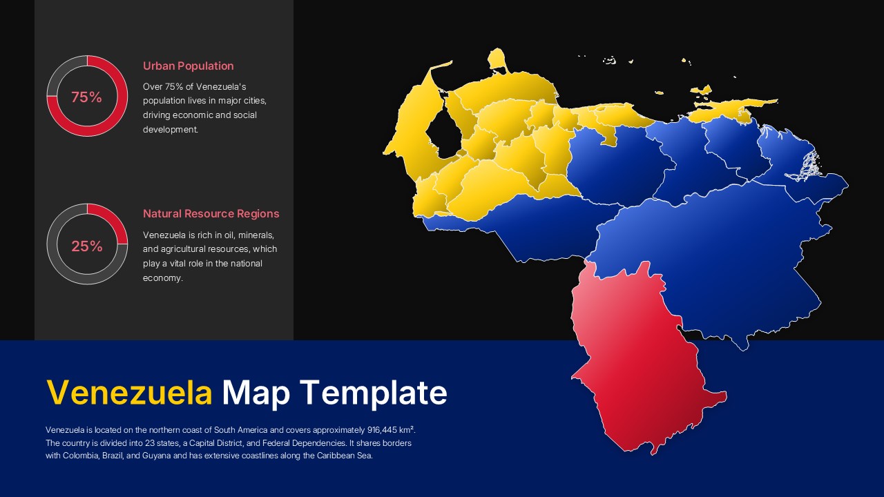
The centerpiece of the slide is a three-dimensional map of Venezuela rendered in the country’s national colors, yellow, blue, and red, with each region clearly delineated and color-coded to support geographic segmentation, regional analysis, or thematic data mapping. Two circular progress chart panels on the left add a data visualization layer that gives the map real analytical weight rather than decorative presence.
- The Urban Population panel displays the statistic that over 75 percent of Venezuela’s population lives in major cities, paired with context on economic and social development implications, making it immediately useful for demographic analysis presentations.
- The Natural Resource Regions panel highlights Venezuela’s oil, mineral, and agricultural resource richness at 25 percent regional weighting, giving energy sector analysts, policy researchers, and economic geography presenters a ready-made data anchor for their narrative.
- The dark navy footer section carries the Venezuela Map Template title alongside a concise country overview covering geographic location, area, state divisions, border countries, and Caribbean coastline details, giving any audience the contextual foundation they need before the deeper analysis begins.
Explore our World Maps for additional country and regional map designs that support geographic storytelling and data visualization.
Frequently Asked Questions
What is a Venezuela Map Template and what is it used for?
A Venezuela Map Template is a pre-designed presentation slide featuring an editable map of Venezuela with regional divisions, color-coding, and data visualization panels for presenting geographic, demographic, or economic information. It gives presenters a professional visual foundation for any Venezuela-focused analysis without building the map from scratch.
What other use cases does this Venezuela Map Template support beyond geographic presentations?
Beyond geography presentations, this template adapts well to market entry analysis for South American business expansion, oil and energy sector briefings, regional demographic research decks, international relations academic presentations, development aid program proposals, and Latin American economic policy discussions where a clear, data-supported visual of Venezuela's regional landscape is needed to inform decisions or educate audiences.
Login to download this file
What do you think of this template?
-
Category:
Infographics -
-

-

Aspect Ratio: 16:9
-

Item ID: SPT1079
-

Designed by: Niranjana
-

Color
Related Templates
-

-

-

-

-

-

-

Creative Mind Map Infographics Presentation Template
Google Slides
-

7 Continents 5 Oceans Map Presentation Template
Infographics
-
Stacked Column Chart PowerPoint Google Slides Template
Charts & Graphs
-

-
Growth Chart Infographic Template
Charts & Graphs
-


